Creating a firm foundation for your AEC requirements, scan-to-BIM Modeling stands out. At the intersection of traditional construction methods and evolving digitized solutions, the importance of accurate scanning and intelligent modeling cannot be overstated.
This technique integrates 3D laser scanning technology with advanced building information modeling software, commonly known as Scan to BIM Services. A digitized transformative process facilitates the creation of accurate and detailed digital twins, or replicas of existing structures, enabling architects, engineers, and construction professionals to collaborate to unlock a future with efficiency and excellence.
Overcoming traditional construction lifecycle management challenges such as design misalignment, manual measurement errors, and fragmented documentation, this technology-driven environment simplifies the entire process. Without a doubt, there are no more horrors in documenting facilities and construction sites with outdated or manual approaches.
The development of Scan to BIM workflows
Accurate construction outcomes begin with a structured scan-to-BIM workflow designed to eliminate guesswork. The process starts with deploying high-precision 3D laser scanners, which capture millions of measurable points across the building surface, generating a precise point cloud that reflects true site conditions. These scanners can detect even millimeter-level deviations that manual surveys might overlook.
The first step is to define the required level of detail, element specifications, and model use case to ensure modeling accuracy, be it coordination, fabrication, or renovation. This clarity eliminates data gaps during scanning and sets expectations for output precision. Planning also includes selecting scanner type and scan positions to avoid blind spots and shadow zones.
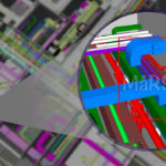
Once scanning is complete, point clouds are cleaned, aligned, and registered. Advanced registration software corrects for overlaps and distortions, ensuring that the merged dataset represents true geometry. This step directly impacts modeling accuracy, as a distorted point cloud would lead to misaligned BIM geometry.
The processed point cloud is then imported into BIM tools, where modelers replicate existing conditions. Here, quality control is critical. Deviations between the point cloud and the model are continuously checked. This data-driven approach aligns the model with real-world conditions, leading to better coordination, fewer RFIs, and less on-site rework.
Step-by-Step process: How does it work?
- Defining accuracy objectives—The process starts with identifying accuracy-sensitive areas of the project, such as load-bearing elements, structural offsets, or tight tolerance zones. This defines the modeling scope, element types, and critical LOD based on end use.
- Optimizing scan setup strategy—Technicians develop a precise scan route and location plan. Coverage, scanner angle, and field overlap are adjusted to avoid distortion and maintain uniform point density across critical architectural and structural zones.
- Capturing as-built conditions—High-resolution terrestrial laser scanners are deployed to record the existing site or structure. These scanners capture millions of spatial coordinates per second, creating a point cloud that reflects every dimension and deviation in the physical environment.
- Aligning and validating point cloud data—The raw scan files are merged and cleaned to remove outliers. Advanced registration algorithms are used to stitch the data into a single coordinate system, maintaining positional integrity for modeling accuracy.
- Precision-based BIM modeling— Scanned data is imported into a BIM platform like Revit, where each modeled component is created by snapping to exact scan points. Verification steps reduce deviations from real-world geometry are minimized, resulting in a model that is geometrically consistent with the actual structure

Applications of 3D Laser Scanning for BIM
Precision-Based Design Decisions—Laser scans provide millimeter-level detail of existing site conditions. These scans are converted into BIM models with precise dimensions, reducing spatial errors in planning and design layouts.
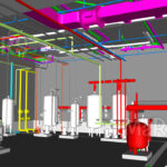
Clash-Free MEP Coordination—It supports early detection of structural or MEP interferences by creating detailed and true-to-site BIM environments. This prevents costly site-based rework caused by misaligned ducts, pipes, or beams.
Construction QA/QC Benchmarking—High-resolution scan-to-BIM workflows act as a benchmark for comparing design intent vs actual build. Any misalignment in construction is detected early, enhancing on-site accuracy and reducing tolerance-based delays.
Structural Deviation Detection—Post-construction scanning enables overlaying actual structures against the model. This allows verification of critical load-bearing alignments, slab deflection, and beam misplacements for enhanced structural compliance.
Digital Twin for Lifecycle Accuracy—It enables creating highly accurate digital twins for long-term use. This accuracy supports asset tracking, maintenance scheduling, and energy management throughout the building lifecycle.
Challenges and Limitations—Accuracy-Focused Scenarios
Scan Drift in Multi-Floor Environments—In complex vertical projects, scan data may misalign across levels if not properly geo-referenced. This can reduce vertical modeling accuracy unless controlled through registration techniques or survey control points.
Edge-Condition Errors in Point Clouds— Sharp corners, narrow voids, or reflective materials can distort laser returns, affecting the fidelity of wall-to-wall measurements or tight-structure modeling accuracy.
Inconsistent LOD Execution—Accuracy drops when different teams interpret the required Level of Detail (e.g., LOD 300 vs LOD 350) inconsistently across disciplines. Without centralized modeling standards, it may result in fragmented accuracy zones.
Scan to BIM Automation Tools
In design and construction projects, accuracy often suffers during manual translation of site data into BIM models. These automation tools directly target this issue by eliminating interpretation gaps between field data and digital output. In façade retrofitting, automated geometry extraction supports accurate alignment of curtain walls and glazing systems by recognizing edges and surfaces from 3D scanned data within millimeter tolerances critical for pre-fab installations. Automation identifies clashes early by generating MEP routings from the scan itself, rather than relying on outdated drawings or assumptions.
Automated feature recognition drastically improves spatial accuracy across multiple scan zones, including in large buildings or high-rise structures. Algorithms keep floor levels and vertical systems consistent, reducing differences in height, slope, and alignment. This helps make BIM coordination easier and avoids mistakes building up during construction steps. It lets teams use the model as a clear and trusted reference during design, fabrication, and work on site.
Where Scan to BIM Delivers the Greatest Accuracy Gains
Scan to BIM should be used early, before design decisions are made, to avoid rework caused by incorrect field data. Starting during the initial survey provides accurate site conditions for detailed, clash-free modeling. Early use is key when structural alignment or MEP routing depends on precise geometry, improving accuracy from design to installation.
Energy Efficiency Analysis
This enables the creation of accurate digital models that reflect a building’s real conditions. These models can be used to analyze insulation, HVAC efficiency, and daylighting performance. Designers can simulate energy usage and implement improvements that reduce waste and support sustainability goals.
Digital Documentation
It transforms traditional documentation by creating data-rich 3D models from scans. It provides complete spatial and geometric accuracy. This digital record serves as a reliable source for all project phases, enhancing coordination, reducing errors, and improving decision-making.
2D Visualization
Converting point cloud data into 2D drawings improves clarity and precision in planning. Scan to BIM-based visuals reflect dimensions and geometry. This results in cleaner sections, accurate floor plans, and reliable documentation, minimizing misinterpretation during design reviews and site execution.
Facility Management
Accurate BIM models created from laser scans help facility managers understand the exact layout and systems of a building. With up-to-date spatial and asset data, they can plan maintenance, track equipment, and manage space efficiently. This leads to fewer errors, better decisions, and optimized building performance over time.
Renovation and Retrofitting
It captures existing building details with high accuracy, allowing teams to plan renovations based on actual conditions. This reduces demolition surprises, design clashes, and field changes. By modeling around structures, retrofitting becomes faster, more efficient, and far more accurate saving both time and cost.
Regulatory Compliance Through BIM Accuracy
With the captured existing site data with high precision, helping teams create models that reflect actual building conditions. This accuracy supports adherence to building codes, safety standards, and local regulations. With reliable documentation, approvals become smoother, and the risk of non-compliance penalties is minimized.
Accurate Construction Planning
Planners get precise as-built data early in the project, allowing them to align design intent with actual site conditions. This improves scheduling, clash detection, and phase-wise execution. It minimizes delays caused by unforeseen issues ensuring construction progresses accurately and efficiently from day one.
Land Mapping & Survey Accuracy
It enhances accuracy in site planning by capturing exact topography, boundaries, and elevations through laser scanning. It eliminates human error and provides detailed data for terrain modeling. This precision helps foundations, utilities, and structures align correctly from the start, reducing rework and design conflicts..
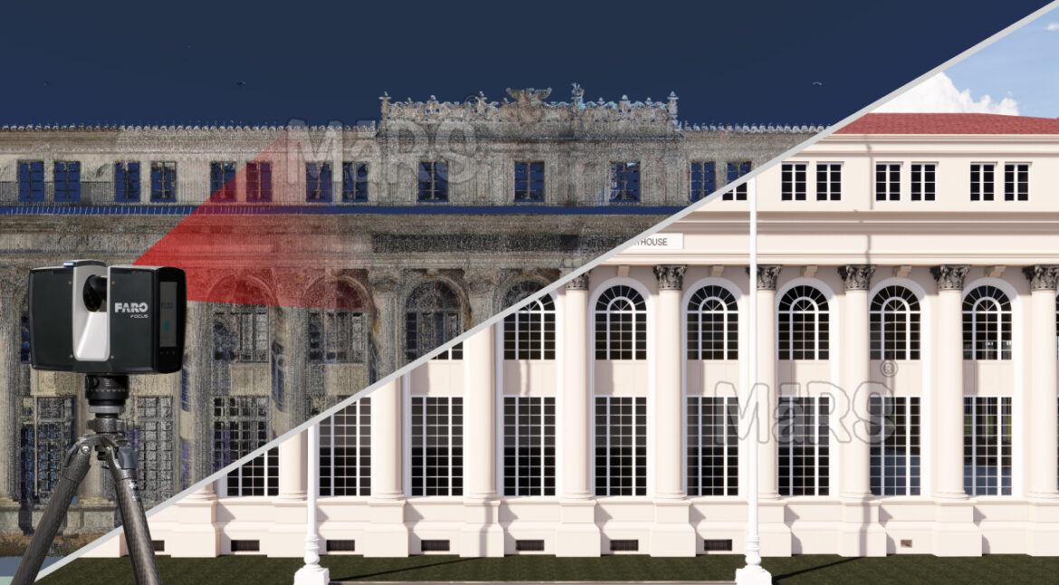
Rapid As‑Built Capture of Heritage Building
This process provides accurate as-built data by capturing existing conditions with millimeter-level precision. It removes the guesswork of outdated drawings and manual site measurements. This enables design teams to model around real conditions, reducing coordination errors and helping retrofits, additions, or repairs fit correctly upon installation.
Conclusion
Scan to BIM services actively transform how teams achieve accuracy in design and construction. Instead of relying on outdated plans or site assumptions, professionals capture conditions using laser scanning and convert them into intelligent 3D BIM models. This direct integration of site data helps architects and engineers avoid dimensional errors, resolve coordination issues early, and build with confidence. From detecting structural misalignments to improving MEP system routing, every design decision becomes grounded in verified data. On construction sites, teams reduce rework, accelerate approvals, and maintain tighter schedules. By embedding precision into every phase of planning, design, and execution. Scan to BIM doesn’t just support project accuracy; it drives it as a competitive advantage.