Increasing concern is turning towards efficiency in the construction industry, which keeps changing quickly. It is good to note that all these projects must be planned well before they start; hence, there is a need for close monitoring within every step of the execution process to accomplish them promptly or within budget. Architects, engineers, and constructors may make more of their time through software applications which would enhance quick decision-missing without affecting the quality of what they opt to go for. User-friendly, compelling, and synergistic technologies like Cloud, Big Data, IoT, Automation, and Robotics are driving the geospatial industry as a result of the integration of geospatial technology with mainstream IT and engineering. To help increase overall workflow efficiency in construction, this article will look at what geospatial engineering solutions can achieve while optimizing your construction workflow.
Exploring Geospatial Engineering Services
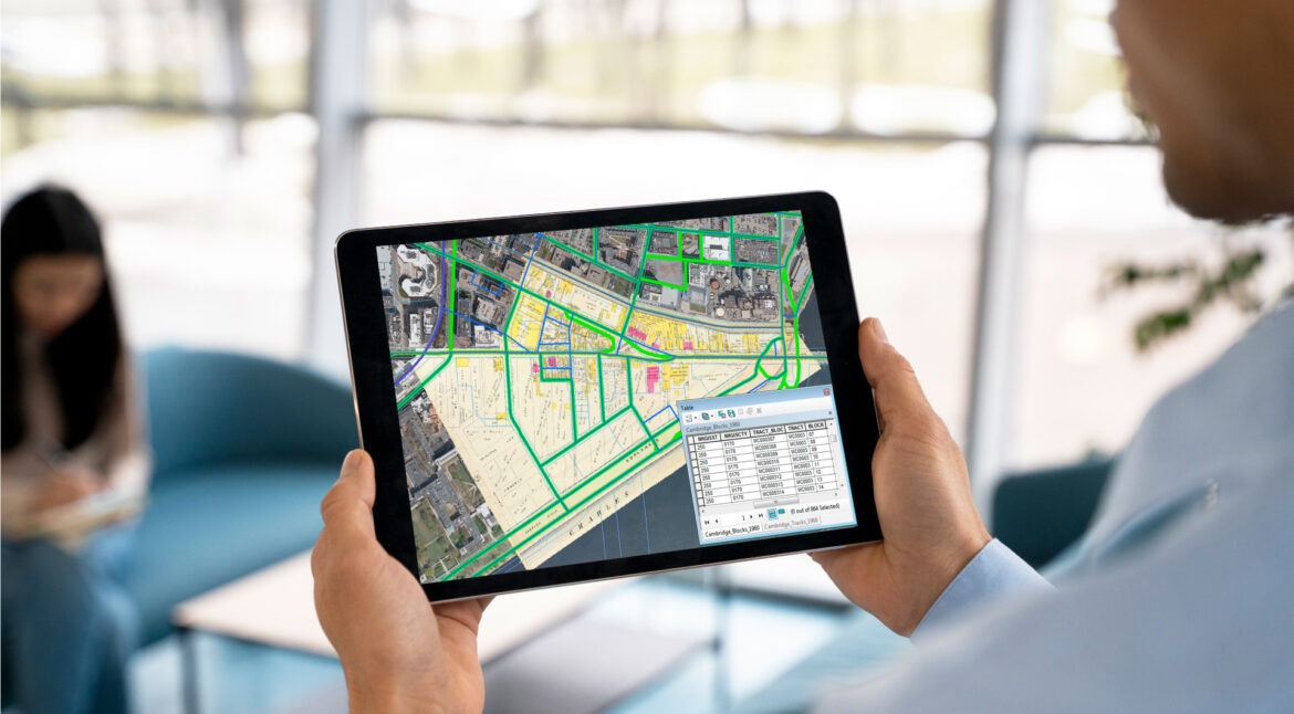
Geospatial engineering services refer to different approaches and systems used in collecting, assessing, and displaying data. Such techniques are based on devices like Global Positioning Systems (GPS), Geographic Information Systems (GIS), LiDAR or Light Detection and Ranging, remote sensing, aerial imaging etc., which help gather information about the earth’s surface, structures and environmental features. When this knowledge is incorporated into construction processes it provides stakeholders with insight into site context, existing buildings, dangers or opportunities that may arise hence enabling them to make well-founded decisions throughout project implementation.

Workflow Optimization
Geo-engineering services expand possibilities for collaboration among stakeholders by providing a readily available platform where project data can be shared. This allows them to work towards shared objectives and make informed real-time decisions throughout the construction process. Below are some instances of how this service helps improve the workflow in construction:
Enhancing Site Evaluation and Designing
Geographic information is used by engineering services for project planning and site assessment. This helps construction experts choose the site, conduct feasibility studies, and identify problems. Project implementation can be supported by optimizing the placement of facilities, making decisions about where to locate projects with a good understanding of their surroundings or using mapping tools that show different areas on the earth’s surface together with methods like space analysis.
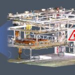
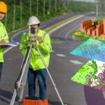
Accuracy in Surveying
Accurate surveying is essential for construction projects as it sets the stage for design and building tasks. Geospatial engineering services bring in surveying methods that are better than any other way to enable construction teams to get highly accurate information. On-site surveys drone mapping and LiDAR technology use is carried out which help produce topographic maps 3D terrain models and BIM that are essential throughout the entire construction process.

Improving Design and Visual Representation
Architects, engineers, and urban planners could understand site conditions and interconnections by leveraging GIS and Scan to BIM technologies. In turn, this allows them to accurately represent what exists now and what might happen ecologically if certain buildings were put up. Data-driven visualization tools can help stakeholders evaluate design scenarios against potential problems before they arise and their workability before anything is built.
Enhancing Construction Management
Geospatial engineering services are involved in the supervision and control of projects while constructing something. Coordinating is facilitated by tracing equipment, materials,, and employees at different times. This enables one to think ahead to deal with any possible setbacks or difficulties. Project managers can then be able to see dashboards and analytics that provide practical knowledge about the advancement of a project, productivity levels, and resource utilization.
Improved Risk Management
By analyzing information and creating maps of hazards, developers may identify risks such as steep inclines, unstable soil or proximity to utilities, among others. With the help of GPS tracking and remote sensing technology in real-time monitoring, project managers can reduce possibilities for accidents or injuries by being quick enough to recognize new threats.

Future of Geospatial Workflows
The sector of geospatial technology is experiencing rapid change and offering various ways to meet the information requirements of people, governments, and businesses. With business IT becoming more customer-centric and big data plus GIS becoming available on any device for all people, location-based applications as well as services are becoming more common. Mobile devices have made geographical information widely available, leading to web-based geospatial services; thus, anyone can participate in volunteer geographic information projects (VGI) or use these services in their day-to-day life as neo-geographers. This will be achieved through attribute data produced by billions of devices worldwide according to the Internet of Things, which shall also generate lots of location information.
Conclusion
In the construction sector, geospatial engineering services play a vital role in making things different. In this regard, building enterprises are provided with a whole set of instruments and technologies that can help them improve their decision-making processes, streamline workflows, and enhance efficiency at each phase of project implementation of spatial information systems. Whether it is site analysis and planning for design visualization or construction management environmental mitigation measures, spatial data alongside tools assist decision makers in choosing wisely and lowering risks involved while ensuring the successful completion of projects.